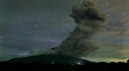


NEW YORK: New discoveries about ash clouds could help predict where planes can safely fly following volcanic eruptions, researchers have said.
Scientists have studied ash grains recovered from recent and previous Icelandic eruptions to compare satellite-based measurements of ash clouds with ash deposits on the ground.
It is hoped their findings will help improve methods of mapping ash concentration in order to identify zones where it is safe to fly during future eruptions.
Hundreds of flights were cancelled in 2010 and 2011 following volcanic activity in Iceland, because of the danger that volcanic ash posed to aircraft and their engines.
Dr John Stevenson, of the University of Edinburgh’s School of GeoSciences, who led the study, said: “Mapping volcanic ash clouds and their risk to aircraft is hard.
“Large regions of airspace can be contaminated by particles that are invisible to the naked eye.
“Combining the expertise of volcanologists and atmospheric scientists should help improve forecasts.”
Researchers studied volcanic ash recovered in the UK from the recent Eyjafjallajokull and Grimsvotn eruptions in Iceland, as well as prehistoric samples from peat bogs in Scotland, Ireland and Yorkshire.
Another sample, from an 1875 eruption, had been in a museum for 140 years.
Ash grains were found to be much larger than typically estimated by satellites, while calculations showed that even moderately-sized eruptions could disperse large grains as far as the UK.

Pakistan to get $3b loan from Islamic Trade Financing Corporation
ISLAMABAD: Islamic Trade Financing Corporation (ITFC) to provide Pakistan with a $3 billion loan, according to an official statement released...