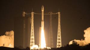


LONDON: The European Space Agency (ESA) has launched the Sentinel-2A satellite from Europe’s Spaceport in Kourou, French Guiana on Wednesday with the mission anticipated to send back images of the Earth’s surface in visible and infrared light.
The data the 1.1 tonne satellite would return will map everything from the rise of megacities to the aftermath of natural calamities such as earthquakes. Sentinel 2A, in particular, is tasked to monitor the performance of the food crops worldwide.
“Sentinel-2 is a polar-orbiting, multispectral high-resolution imaging mission for land monitoring to provide, for example, imagery of vegetation, soil and water cover, inland waterways and coastal areas. Sentinel-2 will also deliver information for emergency services,” ESA said.
The satellite’s camera sensor will detect wavelengths of light that would provide details on the health of plants and this could provide agriculture and food agencies advance notice of potential famines or poor harvests.

Karachi Port sets 138-year cargo handling record
KARACHI: Pakistan's maritime sector has achieved a major milestone as Karachi Port set a new record in its 138-year history...