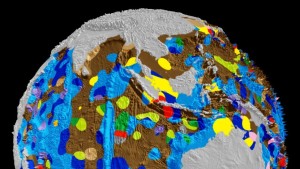
LONDON: We know less about the bottom of our oceans, the saying goes, than we know about the surface of the Moon. But the first map of the Earth’s seafloor in 40 years, and the first one to be digitised, reveals unprecedented new levels of detail.
A team from the University of Sydney used 15,000 samples taken by cruise ships over the last half century to construct a clear picture of the geology of the sea floor around the globe. A sophisticated algorithm was used to turn those point observations into a continuous digital map.