LONDON: Scientists have long-wondered what lies beneath the world’s tectonic plates, which cause earthquakes and volcanoes around the world.
A Kiwi-led team of scientists has detonated hundreds of kilograms of dynamite deep below the North Island to reveal the clearest picture yet of what happens beneath tectonic plates.


An important breakthrough, led by New Zealand scientists and published today in the leading journal Nature, has transformed our understanding of the Earth’s tectonic plates.
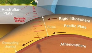
It shows for the first time how they are gliding on a distinct layer of “soft” rock, only 10km thick and weak enough to allow the plates to shift many centimetres per year.
While the idea that the Earth’s surface was made up of at least 16 tectonic plates, moving at different rates, is well established, until now it has not been clear what actually shifts them around.
“To work this out requires an understanding of what happens at the bottom of a tectonic plate,” said Professor Tim Stern of Victoria University, who worked alongside GNS Science and universities from the US and Japan on the research.
Previously, it had been difficult to get the necessary images at such great depths using the usual method of recording natural earthquake waves.
“But by generating our own seismic waves using higher frequency dynamite shots we were able to see how they became modified as they passed through different layers in the earth,” he said.
“This, along with some new techniques in seismic reflection processing, allowed us to obtain the most detailed image yet of an oceanic tectonic plate.”
The create their waves, the team used 1200 portable seismographs placed in a
long line between the Wairarapa and Kapiti coasts.
By setting off explosive charges in the ground and recording the echo with seismic instruments, the scientists were able to build a three-dimensional picture of geological layers to a depth of about 100km below the lower North Island.
The initial focus was the top 50km of subsurface to see how the Pacific and Australian plates interact.