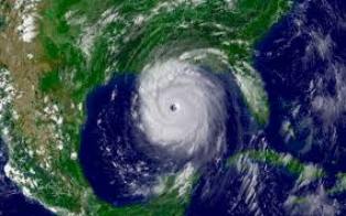


LONDON: On August 28th, 2005, the National Hurricane Center issued a public notice warning people in New Orleans of “devastating damage expected…power outages will last for weeks…persons…pets…and livestock left exposed to the winds will be killed,” from the ensuing Hurricane Katrina.
The storm had formed near the Bahamas and south Florida before becoming a Category 2 hurricane over the Gulf region northwest of Key West. Then, in two days, the hurricane’s winds almost doubled to 175 mph, creating Category 5 Hurricane Katrina— the most intense hurricane in the past 36 years.
By the time Hurricane Katrina hit the U.S. Gulf Coast, the storm had lost strength but was still able to cause immense damage. Even though the destruction was high, the damage could have been worse if it were not for the forecasts.
But no matter how accurate the track forecast, there are still mysteries to solve about hurricane behavior to further improve forecasting.
Researchers are particularly interested in improving forecast lead-time, track and intensity forecast, which are essential to plan successful evacuations. With its expertise in space and scientific exploration, NASA provides help for essential services to the American people, such as hurricane weather forecasting. NASA satellites, computer modeling, instruments, aircraft and field missions provide valuable information to help scientists better understand these storms.

Karachi Port sets 138-year cargo handling record
KARACHI: Pakistan's maritime sector has achieved a major milestone as Karachi Port set a new record in its 138-year history...