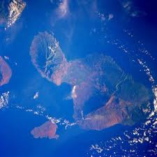

NEW YORK: We know Hawaii Island is gorgeous, but this is a vantage we don’t often see.While Hawaii Island’s residents and visitors were hiking, enjoying the beach, eating plate lunches and generally going about their day last Saturday, European Space Agency astronaut Samantha Cristoforetti was hovering some 200 miles above them taking this picture.
The mostly-cloudless photo of Hawaii’s biggest island depicts its east-facing Hamakua Coast in the foreground. Hilo Bay, with the city behind it, notches the coastline. To the left of Hilo Bay, volcanic plumes rise from Kilauea volcano’s Puu Oo cone eruption and Halemaumau summit crater in Hawaii Volcanoes National Park. The image shows massive Mauna Loa volcano dominating the island’s center, with its brown, treeless upper-elevation slopes stretching in all directions. Mauna Kea, one of the tallest mountains in the world when measured from sea floor to summit, is seen to the right of Mauna Loa, ringed by light-brown upper-elevation acreage and green forests and pasturelands north (right) of Hilo.
The photo was taken from the International Space Station as part of NASA’s Crew Earth Observation program, which captures images of Earth from space to look for changes over time.

Tesla driverless system to use updated radar technology
WASHINGTON: Electric carmaker Tesla announced Sunday it was upgrading its Autopilot software to use more advanced radar technology. In a...