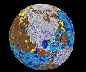


CANADA: Scientists have created the world’s first digital map of Earth’s ocean floor.
The oceanic atlas, compiled by scientists from the University of Sydney, is the most detailed map of the seabed ever created.
Professor of Geophysics, Dietmar Müller, said the last time a complete map was made of the seafloor was in the 1970s.
Since then, scientists have learned more about the topography of Mars than the submarine surface of our own planet.
“Ocean sediments cover about 70 per cent of our planet,” Professor Müller said,
“And is home to the largest ecosystem on earth, but we know very little about it.
“What we’ve discovered is the seabed is much more complex than what was originally thought.”
The map is the result of more than a year of research in which scientists sifted through thousands of seabed samples generated by independent expeditions.
“A couple of years ago, we got involved in a big data discovery project,” Professor Müller said.
“We realised we had no decent geology map of the seafloor.
“The last time it was done was in the 1970s, it had been drawn by hand over a light table.
“Even though nearly 200,000 seafloor samples have been taken, by many different research vessels in different countries over the last half century, nobody had gone and actually combined all this information into an improved map.”

Pakistan to get $3b loan from Islamic Trade Financing Corporation
ISLAMABAD: Islamic Trade Financing Corporation (ITFC) to provide Pakistan with a $3 billion loan, according to an official statement released...