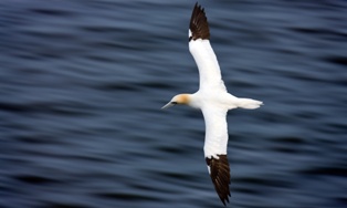


NEW YORK: A team of researchers from the United Kingdom have developed a way to track the flight path of northern gannets during their hunt for food.
The new experimental project, known as Tag A Gannet (TAG), aims to measure the distance the seabirds travel in order to gather fish for their offspring. It was created by wildlife experts from the Alderney Wildlife Trust, the University of Liverpool and the British Trust for Ornithology (BTO).
According to TAG researchers, the project makes use of Global Positioning System (GPS) tags uploaded onto the Internet to allow people to see how the largest seabirds in Britain travel through the English Channel from their nests located in the Channel Islands to look for prey.
The system has already recorded a fishing run by one of the northern gannets that covered a total distance of about 500 miles. Another seabird was also monitored flying up as far as the estuary of the Thames.
The researchers placed tracking devices on the tail feathers of several northern gannets that help monitor the birds’ location. The data collected from the tags are uploaded to the web whenever the gannets come into close contact with 3G-enabled mobile networks.
The flight path of the birds can be tracked in real time through the TAG project’s website.
The site also features several live streaming videos of the northern gannets taken by webcams placed at the birds’ 25-meter high nest found three miles offshore. There are around 2,200 pairs of gannets found in this location.

Pakistan to get $3b loan from Islamic Trade Financing Corporation
ISLAMABAD: Islamic Trade Financing Corporation (ITFC) to provide Pakistan with a $3 billion loan, according to an official statement released...